An Stùc
Scottish Gaelic: [ən̪ˠˈs̪t̪uxk]

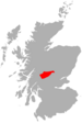
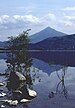
An Stùc, meaning "The Peak" in Gaelic, is a conically shaped Scottish mountain in the Ben Lawers range to the north of Loch Tay. It has been listed as a Munro since 1997, having previously been considered a subsidiary top of the Ben Lawers range.[3] It lies on the main ridge of the Ben Lawers range, and its southern and eastern slopes form part of the Ben Lawers National Nature Reserve, which is owned and managed by the National Trust for Scotland.[1]
The normal routes of ascent are via the ridges from Ben Lawers or Meall Garbh, in combination with other summits in the range. It may also be ascended directly from the Lawers Burn to the east via a gully above Lochan nan Cat.[3]
There is another An Stùc in Assynt, standing at 364 m (1,194 ft) about 26 kilometres (16 mi) northeast of Ullapool at the head of Glenoykel.[4]
See also
 mountains portal

References
Wikimedia Commons has media related to An Stùc.
- ^ a b Ordnance Survey Landranger Sheet 51, "Loch Tay & Glen Dochart".
- ^ "An Stuc, Scotland". Peakbagger.com.
- ^ a b Donald Bennet, ed. (1997). The Munros. Scottish Mountaineering Trust. p. vii (The New Munros). ISBN 0-907521-31-2.
- ^ "An Stuc". Hill Bagging: the online version of the Database of British and Irish Hills. Retrieved 23 December 2019.
- v
- t
- e
- An Stùc
- Beinn Achaladair
- Beinn Challuim
- Beinn a' Chreachain
- Beinn Dòrain
- Beinn an Dòthaidh
- Beinn Ghlas
- Beinn Heasgarnich
- Ben Lawers
- Beinn Mhanach
- Càrn Gorm
- Càrn Mairg
- Creag Mhòr
- Meall Corranaich
- Meall nan Aighean
- Meall Buidhe
- Meall a' Choire Leith
- Meall Ghaordaidh
- Meall Garbh (Càrn Mairg Group)
- Meall Garbh (Lawers Group)
- Meall Glas
- Meall Greigh
- Meall nan Tarmachan
- Schiehallion
- Sgiath Chùil
- Stuchd an Lochain
56°33′38″N 4°12′58″W / 56.56044°N 4.21612°W / 56.56044; -4.21612
 | This Perth and Kinross location article is a stub. You can help Wikipedia by expanding it. |
- v
- t
- e


