California Historical Landmarks in Santa Cruz County
Map all coordinates using OpenStreetMap
Download coordinates as:
- KML
- GPX (all coordinates)
- GPX (primary coordinates)
- GPX (secondary coordinates)
List table of the properties and districts — listed on the California Historical Landmarks — within Santa Cruz County, California.
- Note: Click the "Map of all coordinates" link to the right to view a Google map of all properties and districts with latitude and longitude coordinates in the table below.
Listings
| Image | [1] | Landmark name | Location | City or town | Summary |
|---|---|---|---|---|---|
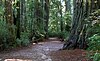 | 827 | Big Basin Redwoods State Park | Big Basin Redwoods State Park 37°10′21″N 122°13′21″W / 37.1725°N 122.2225°W / 37.1725; -122.2225 (Big Basin Redwoods State Park) | Boulder Creek | |
 | 998 | Castro Adobe | 184 Old Adobe Rd. 36°56′45″N 121°48′40″W / 36.9458°N 121.811°W / 36.9458; -121.811 (Castro Adobe) | Watsonville | Also on the NRHP list as NPS-76000531 |
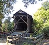 | 583 | Felton Covered Bridge | Covered Bridge Rd. and Graham Hill Rd. 37°03′03″N 122°04′15″W / 37.050797°N 122.070956°W / 37.050797; -122.070956 (Felton Covered Bridge) | Felton | |
 | 449 | Glenwood | 4171 Glenwood Dr. 37°06′29″N 121°59′08″W / 37.108056°N 121.985556°W / 37.108056; -121.985556 (Glenwood) | Scotts Valley | |
 | 342 | Mission Santa Cruz | Plaza Park 36°58′39″N 122°01′43″W / 36.9775°N 122.028611°W / 36.9775; -122.028611 (Mission Santa Cruz) | Santa Cruz | Also on the NRHP list as NPS-76000530 |
 | 1055 | Mystery Spot | 465 Mystery Spot Rd 37°00′45″N 122°00′06″W / 37.0126°N 122.001795°W / 37.0126; -122.001795 (Mystery Spot) | Santa Cruz | |
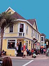
 | 983 | Santa Cruz Beach Boardwalk | 400 Beach St. 36°57′51″N 122°01′04″W / 36.964167°N 122.017778°W / 36.964167; -122.017778 (Santa Cruz Beach Boardwalk) | Santa Cruz | |
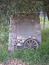
 | 860 | Superintendent's Office | 201 Monterey Ave. 36°58′22″N 121°57′02″W / 36.9729°N 121.9506°W / 36.9729; -121.9506 (Superintendent's Office) | Capitola | |
 | 469 | Villa de Branciforte | Water and Branciforte 36°59′00″N 122°01′00″W / 36.983333°N 122.016667°W / 36.983333; -122.016667 (Villa de Branciforte) | Santa Cruz |
References
- ^ "California Historical Landmarks By County". Ohp.parks.ca.gov. Retrieved 2019-04-03.
See also
Wikimedia Commons has media related to California Historical Landmarks in Santa Cruz County, California.
- List of California Historical Landmarks
- National Register of Historic Places listings in Santa Cruz County, California
- v
- t
- e
| |||||||||||||||||
National Forests and Grasslands | |||||||
|---|---|---|---|---|---|---|---|
| |||||||
|
| |||||||
| |||||||
|
|
- Heritage registers
- National Natural Landmarks


