Haßberge (district)
District in Bavaria, Germany

Flag

Coat of arms

(31 December 2022)[1]
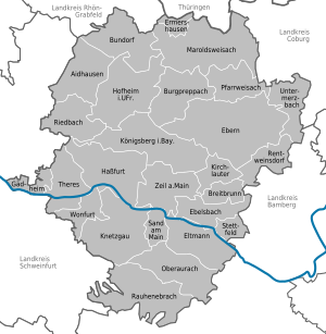
Haßberge is a Landkreis (district) in Bavaria, Germany. It is bounded by (from the northeast and clockwise) the districts of Coburg, Bamberg, Schweinfurt and Rhön-Grabfeld, and by the state of Thuringia (district of Hildburghausen).
History
The district was established in 1972 by merging the districts of Haßfurt, Ebern and Hofheim.
Geography
The district is named after the Haßberge hill chain, which is located south of the Thuringian border. It is an eastern extension of the Rhön mountains and densely forested. South of the hills the Main river crosses the district from east to west. South of the river there is the Steigerwald forest, whose northern parts belong to the district. Both the Haßberge hills and the Steigerwald are nature parks.
Coat of arms
The three jags are from the arms of Würzburg; the lion symbolises the city of Bamberg. These two bishoprics owned most of the region in medieval times. Below there is a motive from the Saxon coat of arms, since the city of Königsberg once belonged to Saxe-Coburg and did not become a part of Bavaria before 1920.
Towns and municipalities
| Towns | Municipalities | |
|---|---|---|
References
- ^ Genesis Online-Datenbank des Bayerischen Landesamtes für Statistik Tabelle 12411-003r Fortschreibung des Bevölkerungsstandes: Gemeinden, Stichtag (Einwohnerzahlen auf Grundlage des Zensus 2011) (Hilfe dazu).
External links
Wikimedia Commons has media related to Landkreis Haßberge.
- Official website (German)
- v
- t
- e
Urban and rural districts in the Free State of Bavaria in Germany
districts
- Amberg
- Ansbach
- Aschaffenburg
- Augsburg
- Bamberg
- Bayreuth
- Coburg
- Erlangen
- Fürth
- Hof
- Ingolstadt
- Kaufbeuren
- Kempten
- Landshut
- Memmingen
- München (Munich)
- Nürnberg (Nuremberg)
- Passau
- Regensburg
- Rosenheim
- Schwabach
- Schweinfurt
- Straubing
- Weiden
- Würzburg
districts
- Aichach-Friedberg
- Altötting
- Amberg-Sulzbach
- Ansbach
- Aschaffenburg
- Augsburg
- Bad Kissingen
- Bad Tölz-Wolfratshausen
- Bamberg
- Bayreuth
- Berchtesgadener Land
- Cham
- Coburg
- Dachau
- Deggendorf
- Dillingen
- Dingolfing-Landau
- Donau-Ries
- Ebersberg
- Eichstätt
- Erding
- Erlangen-Höchstadt
- Forchheim
- Freising
- Freyung-Grafenau
- Fürstenfeldbruck
- Fürth
- Garmisch-Partenkirchen
- Günzburg
- Haßberge
- Hof
- Kelheim
- Kitzingen
- Kronach
- Kulmbach
- Landsberg
- Landshut
- Lichtenfels
- Lindau
- Main-Spessart
- Miesbach
- Miltenberg
- Mühldorf
- München (Munich)
- Neuburg-Schrobenhausen
- Neumarkt
- Neustadt (Aisch)-Bad Windsheim
- Neustadt an der Waldnaab
- Neu-Ulm
- Nürnberger Land
- Oberallgäu
- Ostallgäu
- Passau
- Pfaffenhofen
- Regen
- Regensburg
- Rhön-Grabfeld
- Rosenheim
- Roth
- Rottal-Inn
- Schwandorf
- Schweinfurt
- Starnberg
- Straubing-Bogen
- Tirschenreuth
- Traunstein
- Unterallgäu
- Weilheim-Schongau
- Weißenburg-Gunzenhausen
- Wunsiedel
- Würzburg
Towns and municipalities in Haßberge (district) | ||
|---|---|---|
 | ||
Authority control databases | |
|---|---|
| International |
|
| National |
|
50°05′N 10°40′E / 50.08°N 10.67°E / 50.08; 10.67


