Kiryandongo District
District in Western Uganda, Uganda
02°00′N 32°18′E / 2.000°N 32.300°E / 2.000; 32.300 Uganda
 (2012 Estimate)
Kiryandongo District is a district in Western Uganda. Like many other Ugandan districts, it is named after its 'chief town', Kiryandongo, where the district headquarters are located.
Location

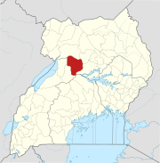
Kiryandongo District is bordered by Nwoya District to the north, Oyam District to the northeast, Apac District to the east, and Masindi District to the south and west. Kiryandongo, the location of the district headquarters, lies approximately 225 kilometres (140 mi) northwest of Kampala, Uganda's capital and largest city.[1] The coordinates of the district are:02 00N, 32 18E (Latitude:2.0000; Longitude:32.3000).
Overview
Kiryandongo District was established on 1 July 2010. It was previously part of Masindi District. The district is part of Bunyoro sub-region, which is coterminous with Bunyoro Kingdom. The districts that constitute Bunyoro sub-region include the following: 1. Buliisa District 2. Hoima District 3. Kibaale District 4. Kiryandongo District and 5. Masindi District. In 2002, the sub-region was home to an estimated 750,000 inhabitants, according to the national population and household census conducted that year.
Population
The 1991 Uganda national census estimated the district population at 83,405. According to the 2002 national census, that population had increased to about 187,700. In 2012, the population of Kiryandongo District was estimated at 317,500.[2] A new national census is planned for August 2014.[3]
See also
References
- ^ "Map Showing Kampala And Kiryandongo With Distance Marker". Globefeed.com. Retrieved 15 April 2014.
- ^ "Estimated Population of Kiryandongo District In 2002, 2010 & 2012". Citypopulation.de. Retrieved 8 May 2014.
- ^ Baguma, Raymond (12 September 2013). "National Population Census for 2014". New Vision. Retrieved 8 May 2014.
External links
Wikimedia Commons has media related to Kiryandongo District.
- Kiryandongo District Homepage
Authority control databases | |
|---|---|
| International |
|
| National |
|
Kiryandongo District | ||
|---|---|---|
Capital: Kiryandongo | ||
| Towns and villages |
|  |
| Geography | ||
| Economy | ||
| Energy | ||
| Notable landmarks | ||
| Transport | ||
| Education | ||
| Health | ||
| Notable people | ||


