List of listed buildings in Stornoway
This is a list of listed buildings in the parish of Stornoway in the Outer Hebrides, Scotland.
Map all coordinates using OpenStreetMap
Download coordinates as:
- KML
- GPX (all coordinates)
- GPX (primary coordinates)
- GPX (secondary coordinates)
List
| Name | Location | Date Listed | Grid Ref. [note 1] | Geo-coordinates | Notes | LB Number [note 2] | Image |
|---|---|---|---|---|---|---|---|
| 1, 3 Cromwell Street And 20 South Beach Thorlee Guest House | 58°12′29″N 6°23′16″W / 58.208165°N 6.387808°W / 58.208165; -6.387808 (1, 3 Cromwell Street And 20 South Beach Thorlee Guest House) | Category C(S) | 41678 |  Upload Photo | |||
| 59-63 (Odd Nos) Cromwell Street and 1 Church Street Loch Erisort | 58°12′35″N 6°23′18″W / 58.209844°N 6.38839°W / 58.209844; -6.38839 (59-63 (Odd Nos) Cromwell Street and 1 Church Street Loch Erisort) | Category B | 41681 |  Upload another image | |||
| 32-38 (Even Nos) Cromwell Street | 58°12′35″N 6°23′20″W / 58.209602°N 6.388889°W / 58.209602; -6.388889 (32-38 (Even Nos) Cromwell Street) | Category B | 41683 | Upload Photo | |||
| Francis Street, Museum (Formerly Free Church Seminary And School Building) | 58°12′34″N 6°22′59″W / 58.209373°N 6.383016°W / 58.209373; -6.383016 (Francis Street, Museum (Formerly Free Church Seminary And School Building)) | Category B | 41689 |  Upload another image | |||
| 2 Goathill Crescent, Wandene Including Boundary Walls And Gatepiers | 58°12′43″N 6°22′54″W / 58.211865°N 6.381671°W / 58.211865; -6.381671 (2 Goathill Crescent, Wandene Including Boundary Walls And Gatepiers) | Category B | 41691 |  Upload another image | |||
| 2 Goathill Road And Matheson Road, Including Boundary Walls Gates And Gatepiers | 58°12′41″N 6°22′57″W / 58.211463°N 6.382371°W / 58.211463; -6.382371 (2 Goathill Road And Matheson Road, Including Boundary Walls Gates And Gatepiers) | Category B | 41692 | Upload Photo | |||
| 4, 6 Goathill Road Including Boundary Wall, Gates And Railings | 58°12′42″N 6°22′55″W / 58.211559°N 6.38194°W / 58.211559; -6.38194 (4, 6 Goathill Road Including Boundary Wall, Gates And Railings) | Category B | 41693 |  Upload another image | |||
| 22, 24 James Street Bellevue House Including Boundary Walls Gates And Railings | 58°12′30″N 6°22′58″W / 58.208311°N 6.382783°W / 58.208311; -6.382783 (22, 24 James Street Bellevue House Including Boundary Walls Gates And Railings) | Category B | 41698 | Upload Photo | |||
| 26 And 27 James Street Including Boundary Walls, Gates And Railings | 58°12′30″N 6°22′57″W / 58.20843°N 6.38244°W / 58.20843; -6.38244 (26 And 27 James Street Including Boundary Walls, Gates And Railings) | Category B | 41699 | Upload Photo | |||
| 67-71 (Odd Nos) Kenneth Street | 58°12′40″N 6°23′17″W / 58.211032°N 6.388111°W / 58.211032; -6.388111 (67-71 (Odd Nos) Kenneth Street) | Category C(S) | 41709 | Upload Photo | |||
| 3, 5 Matheson Road Including Boundary Walls, Gates And Gatespiers | 58°12′37″N 6°22′54″W / 58.21017°N 6.381785°W / 58.21017; -6.381785 (3, 5 Matheson Road Including Boundary Walls, Gates And Gatespiers) | Category B | 41717 | Upload Photo | |||
| 9, 11 Matheson Road Including Boundary Walls, Gates And Railings | 58°12′38″N 6°22′55″W / 58.210639°N 6.382031°W / 58.210639; -6.382031 (9, 11 Matheson Road Including Boundary Walls, Gates And Railings) | Category B | 41719 |  Upload another image | |||
| 2 (Fasgadh), 4 (Brentor), Matheson Road Including Boundary Walls, Gates And Railings | 58°12′33″N 6°22′55″W / 58.209049°N 6.381971°W / 58.209049; -6.381971 (2 (Fasgadh), 4 (Brentor), Matheson Road Including Boundary Walls, Gates And Railings) | Category B | 41723 |  Upload another image | |||
| 6, 7 North Beach | 58°12′30″N 6°23′28″W / 58.208309°N 6.391182°W / 58.208309; -6.391182 (6, 7 North Beach) | Category B | 41733 | Upload Photo | |||
| North Beach Quay/North Beach Old Sail Loft And House Adjoining | 58°12′30″N 6°23′30″W / 58.208432°N 6.391794°W / 58.208432; -6.391794 (North Beach Quay/North Beach Old Sail Loft And House Adjoining) | Category A | 41735 |  Upload another image | |||
| 28, 30 Scotland Street | 58°12′43″N 6°23′03″W / 58.211834°N 6.384138°W / 58.211834; -6.384138 (28, 30 Scotland Street) | Category C(S) | 41736 | Upload Photo | |||
| 3 South Beach, Star Inn | 58°12′29″N 6°23′23″W / 58.208119°N 6.389642°W / 58.208119; -6.389642 (3 South Beach, Star Inn) | Category C(S) | 41739 | Upload Photo | |||
| 14, 15 South Beach | 58°12′29″N 6°23′22″W / 58.20808°N 6.389467°W / 58.20808; -6.389467 (14, 15 South Beach) | Category B | 41740 | Upload Photo | |||
| Lews Castle Driveway Bridge At NGR NB 4210 3321 | 58°12′44″N 6°23′33″W / 58.212123°N 6.392455°W / 58.212123; -6.392455 (Lews Castle Driveway Bridge At NGR NB 4210 3321) | Category B | 18826 | Upload Photo | |||
| Gress Lodge Including Outbuilding To Rear | 58°17′38″N 6°16′42″W / 58.293888°N 6.278398°W / 58.293888; -6.278398 (Gress Lodge Including Outbuilding To Rear) | Category B | 18674 | Upload Photo | |||
| Knock Church Of Scotland At Garrabost Point | 58°13′16″N 6°13′19″W / 58.22125°N 6.221867°W / 58.22125; -6.221867 (Knock Church Of Scotland At Garrabost Point) | Category B | 18675 | Upload Photo | |||
| 20 Bayhead | 58°12′45″N 6°23′15″W / 58.212424°N 6.387636°W / 58.212424; -6.387636 (20 Bayhead) | Category C(S) | 41675 | Upload Photo | |||
| 31-35 Odd Nos Cromwell Street | 58°12′33″N 6°23′17″W / 58.20918°N 6.388087°W / 58.20918; -6.388087 (31-35 Odd Nos Cromwell Street) | Category C(S) | 41680 | Upload Photo | |||
| 4 Goathill Crescent Including Boundary Walls And Railings | 58°12′44″N 6°22′53″W / 58.212106°N 6.381462°W / 58.212106; -6.381462 (4 Goathill Crescent Including Boundary Walls And Railings) | Category B | 41694 |  Upload another image | |||
| Keith Street Industrial Female School | 58°12′40″N 6°23′12″W / 58.211174°N 6.386612°W / 58.211174; -6.386612 (Keith Street Industrial Female School) | Category B | 41702 | Upload Photo | |||
| Matheson Road And Scotland Street, Free Presbyterian Church Including Boundary Walls, Gates And Railings | 58°12′42″N 6°23′00″W / 58.211675°N 6.383283°W / 58.211675; -6.383283 (Matheson Road And Scotland Street, Free Presbyterian Church Including Boundary Walls, Gates And Railings) | Category B | 41730 |  Upload another image | |||
| 8 North Beach | 58°12′30″N 6°23′28″W / 58.208325°N 6.39098°W / 58.208325; -6.39098 (8 North Beach) | Category B | 41734 | Upload Photo | |||
| South Beach, Cromwell Street And Point Street, Municipal Buildings | 58°12′30″N 6°23′19″W / 58.208227°N 6.388616°W / 58.208227; -6.388616 (South Beach, Cromwell Street And Point Street, Municipal Buildings) | Category B | 41738 |  Upload another image | |||
| Tiumpan Head Lighthouse and Attendant Buildings | 58°15′39″N 6°08′21″W / 58.260894°N 6.139095°W / 58.260894; -6.139095 (Tiumpan Head Lighthouse and Attendant Buildings) | Category C(S) | 19209 | 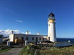 Upload another image | |||
| Gress, Old Church | 58°17′26″N 6°17′03″W / 58.290548°N 6.284125°W / 58.290548; -6.284125 (Gress, Old Church) | Category B | 18673 | Upload Photo | |||
| Cromwells Building Corner Cromwell Street And Francis Street | 58°12′31″N 6°23′17″W / 58.208581°N 6.387979°W / 58.208581; -6.387979 (Cromwells Building Corner Cromwell Street And Francis Street) | Category B | 41679 | Upload Photo | |||
| 23-29 (Odd Nos) Francis Street | 58°12′32″N 6°23′00″W / 58.208998°N 6.383464°W / 58.208998; -6.383464 (23-29 (Odd Nos) Francis Street) | Category C(S) | 41684 | Upload Photo | |||
| 25 Kenneth Street | 58°12′32″N 6°23′13″W / 58.208948°N 6.386985°W / 58.208948; -6.386985 (25 Kenneth Street) | Category C(S) | 41705 | Upload Photo | |||
| Kenneth Street, Masonic Hall Including Boundary Walls, Gatepiers, Railings And Arch | 58°12′38″N 6°23′15″W / 58.21043°N 6.387577°W / 58.21043; -6.387577 (Kenneth Street, Masonic Hall Including Boundary Walls, Gatepiers, Railings And Arch) | Category C(S) | 41708 | Upload Photo | |||
| Lewis Street, Court House | 58°12′36″N 6°23′03″W / 58.209864°N 6.384167°W / 58.209864; -6.384167 (Lewis Street, Court House) | Category B | 41710 |  Upload another image | |||
| 13 Matheson Road Claremont Including Boundary Walls Gates And Gatepiers | 58°12′42″N 6°22′57″W / 58.211797°N 6.382616°W / 58.211797; -6.382616 (13 Matheson Road Claremont Including Boundary Walls Gates And Gatepiers) | Category B | 41720 |  Upload another image | |||
| Lews Castle Driveway Bridge Close To North End Of Mansion | 58°12′43″N 6°23′40″W / 58.21205°N 6.394337°W / 58.21205; -6.394337 (Lews Castle Driveway Bridge Close To North End Of Mansion) | Category C(S) | 18827 | Upload Photo | |||
| Lews Castle | 58°12′42″N 6°23′39″W / 58.211583°N 6.394058°W / 58.211583; -6.394058 (Lews Castle) | Category A | 18677 | 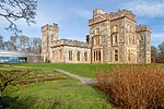 Upload another image | |||
| 67 Keith Street Including Boundary Wall And Railings | 58°12′42″N 6°23′11″W / 58.211545°N 6.386283°W / 58.211545; -6.386283 (67 Keith Street Including Boundary Wall And Railings) | Category C(S) | 50798 | Upload Photo | |||
| Amity House | 58°12′28″N 6°23′30″W / 58.207873°N 6.391588°W / 58.207873; -6.391588 (Amity House) | Category B | 41674 | Upload Photo | |||
| Church Street And Matheson Road Bbc Rosebank Including Boundary Walls And Railings | 58°12′40″N 6°22′59″W / 58.211131°N 6.383148°W / 58.211131; -6.383148 (Church Street And Matheson Road Bbc Rosebank Including Boundary Walls And Railings) | Category C(S) | 41676 | Upload Photo | |||
| 50 Church Street And Lewis Street, Ta Hall Building | 58°12′39″N 6°23′03″W / 58.21076°N 6.384244°W / 58.21076; -6.384244 (50 Church Street And Lewis Street, Ta Hall Building) | Category C(S) | 41677 | Upload Photo | |||
| Francis Street St Peter's Episcopal Church Including Perimeter Wall Gates And Gatepiers | 58°12′33″N 6°22′58″W / 58.209057°N 6.382772°W / 58.209057; -6.382772 (Francis Street St Peter's Episcopal Church Including Perimeter Wall Gates And Gatepiers) | Category B | 41685 |  Upload another image | |||
| 38 ,40 Francis Street | 58°12′33″N 6°23′01″W / 58.20917°N 6.383689°W / 58.20917; -6.383689 (38 ,40 Francis Street) | Category C(S) | 41687 |  Upload another image | |||
| 2 And 4 Garden Road Including Garden Boundary Wall, Gates And Railings | 58°12′32″N 6°22′56″W / 58.208952°N 6.382163°W / 58.208952; -6.382163 (2 And 4 Garden Road Including Garden Boundary Wall, Gates And Railings) | Category B | 41690 | Upload Photo | |||
| James Street And Bells Road, Old Co-Op Yard Buildings | 58°12′28″N 6°22′58″W / 58.207858°N 6.38288°W / 58.207858; -6.38288 (James Street And Bells Road, Old Co-Op Yard Buildings) | Category C(S) | 41695 | Upload Photo | |||
| 18, 20 James Street Including Boundary Walls Gates And Gatepiers | 58°12′29″N 6°23′00″W / 58.208132°N 6.383272°W / 58.208132; -6.383272 (18, 20 James Street Including Boundary Walls Gates And Gatepiers) | Category B | 41697 | Upload Photo | |||
| 28 And 30 James Street, Park Guest House, Including Boundary Walls, Gates And Gatepiers | 58°12′31″N 6°22′56″W / 58.208602°N 6.382154°W / 58.208602; -6.382154 (28 And 30 James Street, Park Guest House, Including Boundary Walls, Gates And Gatepiers) | Category B | 41700 | Upload Photo | |||
| 24 ,26 Lewis Street | 58°12′37″N 6°23′06″W / 58.210261°N 6.384898°W / 58.210261; -6.384898 (24 ,26 Lewis Street) | Category C(S) | 41713 | Upload Photo | |||
| Matheson Road And Goathill Road, High Church Including Boundary Walls, Gatepiers And Railings | 58°12′39″N 6°22′56″W / 58.210968°N 6.382122°W / 58.210968; -6.382122 (Matheson Road And Goathill Road, High Church Including Boundary Walls, Gatepiers And Railings) | Category B | 41722 | 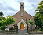 Upload another image | |||
| 6 Matheson Road, Balone, Including Boundary Walls Gate And Railings | 58°12′36″N 6°22′57″W / 58.209892°N 6.382552°W / 58.209892; -6.382552 (6 Matheson Road, Balone, Including Boundary Walls Gate And Railings) | Category B | 41724 | Upload Photo | |||
| 14 Matheson Road Including Boundary Walls Gates And Railings | 58°12′46″N 6°23′02″W / 58.212843°N 6.383836°W / 58.212843; -6.383836 (14 Matheson Road Including Boundary Walls Gates And Railings) | Category B | 41726 | Upload Photo | |||
| 23 Matheson Street And Robertson Road, Including Boundary Walls, Gates And Railings | 58°12′46″N 6°22′59″W / 58.212716°N 6.383088°W / 58.212716; -6.383088 (23 Matheson Street And Robertson Road, Including Boundary Walls, Gates And Railings) | Category B | 41731 | Upload Photo | |||
| Springfield Road School Block And Adjoining Hall | 58°12′37″N 6°22′52″W / 58.210233°N 6.381026°W / 58.210233; -6.381026 (Springfield Road School Block And Adjoining Hall) | Category C(S) | 41741 | 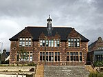 Upload another image | |||
| Ui Church And Graveyard (St Columba's) | 58°12′26″N 6°17′00″W / 58.207119°N 6.283444°W / 58.207119; -6.283444 (Ui Church And Graveyard (St Columba's)) | Category A | 19210 | 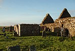 Upload another image | |||
| Lews Castle Creed Lodge Including Gateway And Driveway Bridge Nearby | 58°12′20″N 6°25′10″W / 58.205609°N 6.419352°W / 58.205609; -6.419352 (Lews Castle Creed Lodge Including Gateway And Driveway Bridge Nearby) | Category C(S) | 18816 | Upload Photo | |||
| Knockgarry | 58°12′26″N 6°21′42″W / 58.207349°N 6.361537°W / 58.207349; -6.361537 (Knockgarry) | Category C(S) | 18676 | Upload Photo | |||
| 16, 18 Cromwell Street, The Town House | 58°12′32″N 6°23′18″W / 58.208775°N 6.388377°W / 58.208775; -6.388377 (16, 18 Cromwell Street, The Town House) | Category B | 41682 | 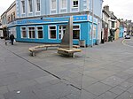 Upload another image | |||
| Matheson Road And 37 Church Street Barvas Lodge Including Boundary Walls Gates And Gatepiers | 58°12′39″N 6°22′59″W / 58.210704°N 6.38301°W / 58.210704; -6.38301 (Matheson Road And 37 Church Street Barvas Lodge Including Boundary Walls Gates And Gatepiers) | Category B | 41729 |  Upload another image | |||
| Lewis War Memorial | 58°13′19″N 6°24′01″W / 58.22194°N 6.400403°W / 58.22194; -6.400403 (Lewis War Memorial) | Category B | 19211 |  Upload another image | |||
| 36 Francis Street | 58°12′33″N 6°23′02″W / 58.209121°N 6.383803°W / 58.209121; -6.383803 (36 Francis Street) | Category C(S) | 41688 | Upload Photo | |||
| 29 Kenneth Street | 58°12′33″N 6°23′13″W / 58.209171°N 6.387063°W / 58.209171; -6.387063 (29 Kenneth Street) | Category C(S) | 41706 | Upload Photo | |||
| 15 Matheson Road The Sheiling, Including Boundary Walls, Gate And Railings | 58°12′43″N 6°22′58″W / 58.21193°N 6.382667°W / 58.21193; -6.382667 (15 Matheson Road The Sheiling, Including Boundary Walls, Gate And Railings) | Category C(S) | 41721 | Upload Photo | |||
| 8 Matheson Road, Park House, Including Boundary Walls, Gates And Gatepiers | 58°12′37″N 6°22′58″W / 58.210194°N 6.382674°W / 58.210194; -6.382674 (8 Matheson Road, Park House, Including Boundary Walls, Gates And Gatepiers) | Category B | 41725 | Upload Photo | |||
| 18 Matheson Road | 58°12′48″N 6°23′03″W / 58.213445°N 6.384115°W / 58.213445; -6.384115 (18 Matheson Road) | Category B | 41728 | Upload Photo | |||
| North Beach Lewis Hotel | 58°12′30″N 6°23′27″W / 58.208343°N 6.390726°W / 58.208343; -6.390726 (North Beach Lewis Hotel) | Category B | 41732 | Upload Photo | |||
| 32 Scotland Street | 58°12′43″N 6°23′01″W / 58.211888°N 6.383633°W / 58.211888; -6.383633 (32 Scotland Street) | Category B | 41737 | Upload Photo | |||
| Springfield Road Tower Of Nicolson Institute | 58°12′32″N 6°22′51″W / 58.20892°N 6.380762°W / 58.20892; -6.380762 (Springfield Road Tower Of Nicolson Institute) | Category B | 41742 |  Upload another image | |||
| Garry Bridge, Beyond Tolsta | 58°22′13″N 6°13′25″W / 58.370226°N 6.223502°W / 58.370226; -6.223502 (Garry Bridge, Beyond Tolsta) | Category B | 18672 |  Upload another image | |||
| 7 James Street | 58°12′28″N 6°23′01″W / 58.207754°N 6.383532°W / 58.207754; -6.383532 (7 James Street) | Category B | 41696 | Upload Photo | |||
| 32 James Street Tower Guest House Including Perimeter Walls, Gates And Railings | 58°12′31″N 6°22′55″W / 58.208722°N 6.381811°W / 58.208722; -6.381811 (32 James Street Tower Guest House Including Perimeter Walls, Gates And Railings) | Category C(S) | 41701 | Upload Photo | |||
| Kenneth Street And Francis Street, Martins Memorial Church And Hall Including Boundary Walls, Gates And Railings | 58°12′31″N 6°23′10″W / 58.20857°N 6.386222°W / 58.20857; -6.386222 (Kenneth Street And Francis Street, Martins Memorial Church And Hall Including Boundary Walls, Gates And Railings) | Category B | 41703 |  Upload another image | |||
| Kenneth Street Free Church | 58°12′34″N 6°23′12″W / 58.209482°N 6.386625°W / 58.209482; -6.386625 (Kenneth Street Free Church) | Category C(S) | 41707 | Upload Photo | |||
| Matheson Road And Springfield Road, Springfield House | 58°12′35″N 6°22′54″W / 58.209798°N 6.38162°W / 58.209798; -6.38162 (Matheson Road And Springfield Road, Springfield House) | Category B | 41716 | Upload Photo | |||
| 7 Matheson Road Including Boundary Walls, Gates And Gatepiers | 58°12′38″N 6°22′55″W / 58.210477°N 6.382011°W / 58.210477; -6.382011 (7 Matheson Road Including Boundary Walls, Gates And Gatepiers) | Category B | 41718 |  Upload another image | |||
| 16 Matheson Road, Free Presbyterian Manse, Including Boundary Walls, Gates And Railings | 58°12′47″N 6°23′02″W / 58.213027°N 6.383978°W / 58.213027; -6.383978 (16 Matheson Road, Free Presbyterian Manse, Including Boundary Walls, Gates And Railings) | Category B | 41727 | Upload Photo | |||
| Porter's Lodge, Lews Castle Lodge At Bayhead, Including Quadrant Walls | 58°12′57″N 6°23′13″W / 58.215896°N 6.386855°W / 58.215896; -6.386855 (Porter's Lodge, Lews Castle Lodge At Bayhead, Including Quadrant Walls) | Category B | 18815 |  Upload another image | |||
| Tong, Tong Farmhouse, Former Parish Church Manse Including Gatepiers | 58°14′21″N 6°21′08″W / 58.239186°N 6.352269°W / 58.239186; -6.352269 (Tong, Tong Farmhouse, Former Parish Church Manse Including Gatepiers) | Category C(S) | 50803 | Upload Photo | |||
| 16 Francis Street, Post Office Building | 58°12′32″N 6°23′11″W / 58.208811°N 6.386286°W / 58.208811; -6.386286 (16 Francis Street, Post Office Building) | Category B | 41686 | Upload Photo | |||
| 7 Kenneth Street Religious Book Shop | 58°12′32″N 6°23′14″W / 58.20882°N 6.387327°W / 58.20882; -6.387327 (7 Kenneth Street Religious Book Shop) | Category B | 41704 | Upload Photo | |||
| Lewis Street And Church Street, St Columba's Old Parish Church | 58°12′37″N 6°23′02″W / 58.210313°N 6.383916°W / 58.210313; -6.383916 (Lewis Street And Church Street, St Columba's Old Parish Church) | Category B | 41711 |  Upload another image | |||
| 31 ,33 Lewis Street, Including Garden Walls And Railings | 58°12′42″N 6°23′06″W / 58.211668°N 6.385054°W / 58.211668; -6.385054 (31 ,33 Lewis Street, Including Garden Walls And Railings) | Category B | 41712 | Upload Photo | |||
| Matheson Road And Springfield Road, School Block | 58°12′34″N 6°22′53″W / 58.209378°N 6.381296°W / 58.209378; -6.381296 (Matheson Road And Springfield Road, School Block) | Category B | 41715 |  Upload another image | |||
| Lews Castle, Lodges, Boundary Walls, Sea Walls And Tower Near Stornoway Harbour Including Cuddy Point | 58°12′36″N 6°23′30″W / 58.210105°N 6.391796°W / 58.210105; -6.391796 (Lews Castle, Lodges, Boundary Walls, Sea Walls And Tower Near Stornoway Harbour Including Cuddy Point) | Category A | 19206 |  Upload another image | |||
| Lews Castle, Matheson Memorial | 58°12′33″N 6°23′49″W / 58.209035°N 6.396997°W / 58.209035; -6.396997 (Lews Castle, Matheson Memorial) | Category B | 19207 |  Upload another image | |||
| New Tolsta, Black House (Adjacent To House At Number 48 North Tolsta) | 58°21′09″N 6°12′49″W / 58.352414°N 6.213639°W / 58.352414; -6.213639 (New Tolsta, Black House (Adjacent To House At Number 48 North Tolsta)) | Category C(S) | 19208 | Upload Photo | |||
| Lews Castle, Marybank Lodge Including Gateway | 58°13′00″N 6°24′33″W / 58.216548°N 6.409142°W / 58.216548; -6.409142 (Lews Castle, Marybank Lodge Including Gateway) | Category C(S) | 18817 | Upload Photo | |||
| Cnoc, Former Manse | 58°12′15″N 6°16′51″W / 58.204114°N 6.280816°W / 58.204114; -6.280816 (Cnoc, Former Manse) | Category B | 18671 | Upload Photo |
Key
The scheme for classifying buildings in Scotland is:
- Category A: "buildings of national or international importance, either architectural or historic; or fine, little-altered examples of some particular period, style or building type."[1]
- Category B: "buildings of regional or more than local importance; or major examples of some particular period, style or building type, which may have been altered."[1]
- Category C: "buildings of local importance; lesser examples of any period, style, or building type, as originally constructed or moderately altered; and simple traditional buildings which group well with other listed buildings."[1]
In March 2016 there were 47,288 listed buildings in Scotland. Of these, 8% were Category A, and 50% were Category B, with the remaining 42% being Category C.[2]
See also
Notes
- ^ Sometimes known as OSGB36, the grid reference (where provided) is based on the British national grid reference system used by the Ordnance Survey.
• "Guide to National Grid". Ordnance Survey. Retrieved 12 December 2007.
• "Get-a-map". Ordnance Survey. Retrieved 17 December 2007. - ^ Historic Environment Scotland assign a unique alphanumeric identifier to each designated site in Scotland, for listed buildings this always begins with "LB", for example "LB12345".
References
- All entries, addresses and coordinates are based on data from Historic Scotland. This data falls under the Open Government Licence
- ^ a b c "What is Listing?". Historic Environment Scotland. Retrieved 29 May 2018.
- ^ Scotland's Historic Environment Audit 2016 (PDF). Historic Environment Scotland and the Built Environment Forum Scotland. pp. 15–16. Retrieved 29 May 2018.


