Opdorp
Village in Flemish Region
51°01′39″N 4°13′13″E / 51.02744°N 4.22040°E / 51.02744; 4.22040 Belgium
 (2021)[1]
Opdorp is one of the three towns making up the municipality of Buggenhout in East Flanders, Belgium. Sometimes it's classified in the Denderstreek.
Opdorp is at the geographical centre of Flanders, Belgium. It is also the point at which three provinces meet: Brabant, Antwerp, and East Flanders.[2]
Opdorp developed around a triangular dries (village square). The dries contains a chapel and the village pump. The town hall, school and former monastery were built around the square.[3]
Gallery
-
 Dries chapel and village pump
 -
 Former brewery Van Den Bossche
 -
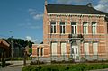
 Former town hall
 -
 St Amandus Church


See also
- Nil-Saint-Vincent-Saint-Martin
References
External links
 Media related to Opdorp at Wikimedia Commons
- Official site (in Dutch)
| Authority control databases |
|
|---|
- v
- t
- e


