Parkway Villages, Houston

Parkway Villages is a 577-lot,[1] 224-acre (91 ha) subdivision in western Houston, Texas.[2] It is located north of Lakes of Parkway, the former Barnhardt land tract.[3] It was the first single family housing development by Sueba USA,[4] a subsidiary of Süba Freie Baugesellschaft.[5]
History
The project's development began in 1993.[2] It was developed in a joint venture between Sueba USA and Hypo-Bank of Munich. It was built in an area that was originally supposed to have a 563-acre (228 ha) office park. That office park, which had been developed for about $70 million,[4] was not built due to the 1980s oil bust. Michael Baldwin of Sueba stated that originally, the buyers of houses in Parkway Village were retirees.[6] The original plan called for 464 lots.[4] From February to October 1993, the first 43 houses in the development were sold.[4]
Ralph Bivins of the Houston Chronicle wrote that this subdivision "was key to Sueba's winning the Developer of the Year award from the Greater Houston Builders Association."[2] By 2002 the building of houses was almost complete. In 2002 Bivins stated that Lakes of Parkway was "one of the largest communities to be developed inside city limits in recent years."[2] Development of houses in the subdivision ended in 2003.[1]
Cityscape
In 1993 Michael W. Baldwin, the sales manager, stated that the housing prices will have the range $200,000 ($420,000 with inflation) to $800,000 ($1,690,000 with inflation).[4]
Government and infrastructure
Harris Health System (formerly Harris County Hospital District) designated Valbona Health Center (formerly People's Health Center) in Greater Sharpstown for ZIP code 77077. The nearest public hospital is Ben Taub General Hospital in the Texas Medical Center.[7]
Education

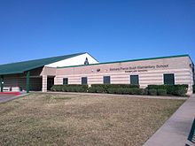
The community is located in the Houston Independent School District (HISD). Two schools, Barbara Bush Elementary School and West Briar Middle School, are located in the community.[6] Residents are zoned to Bush,[8] West Briar,[9] and Westside High School.[10] Residents zoned to Ashford, Askew, Bush, and Daily may attend Shadowbriar Elementary School's magnet program.[11] At one time residents zoned to Westside were allowed to automatically transfer to Lamar High School.[12]
In 2003 Baldwin stated that the typical buyer in Parkway Villages is a family attracted to the area schools.[6]
Bush opened in 1992.[13] Westside opened in August 2000.[14] West Briar, a name combining those of Westheimer Road and Briar Forest, opened in 2002.[15] Previously residents were zoned to Revere Middle School,[16] and Lee High School (formerly Margaret Long Wisdom High School).[17]
References
Wikimedia Commons has media related to Parkway Villages, Houston.
- ^ a b "Completed" (Archived 2014-05-02 at the Wayback Machine) Sueba USA. Retrieved on May 1, 2014.
- ^ a b c d Bivins, Ralph. "Bivins: German group adds to its influence in west Houston." Houston Chronicle. February 24, 2002. Retrieved on April 30, 2014.
- ^ Bivins, Ralph. "Sueba USA acquires land for housing." Houston Chronicle. Thursday June 24, 1993. Business p. 1. Available from NewsBank, Record Number: 06*24*1137595. Anyone with a Houston Public Library card may read this article over the internet.
- ^ a b c d e Stuart, Lettice. "Subdivisions for Houston's Ghostly Business Parks." The New York Times. October 10, 1993. Retrieved on April 30, 2014.
- ^ Bivins, Ralph. "Sueba on the move - Developer plans five new projects this year." Houston Chronicle. Sunday June 27, 1993. Business p. 6. Available from NewsBank, Record Number: 06*27*1137991. Anyone with a Houston Public Library card may read this article over the internet.
- ^ a b c Feser, Katherine. "Unusual luck created cluster of gated villages." Houston Chronicle. Sunday August 24, 2003. Retrieved on April 30, 2014. Available from the Houston Public Library newspaper service, accessible with a library card number and PIN.
- ^ "Clinic/Emergency/Registration Center Directory By ZIP Code". Harris County Hospital District. 2001-11-19. Archived from the original on 2001-11-19. Retrieved 2021-04-08. - See ZIP code 77077. See this map for relevant ZIP code.
- ^ "Bush Elementary Attendance Zone Archived 2013-12-28 at the Wayback Machine." Houston Independent School District.
- ^ "West Briar Middle Attendance Zone Archived 2012-02-08 at the Wayback Machine." Houston Independent School District.
- ^ "Westside High School Attendance Zone Archived April 7, 2014, at the Wayback Machine," Houston Independent School District.
- ^ "Energy Corridor Boundaries" (Archived 2016-03-18 at the Wayback Machine). Houston Independent School District. Retrieved on March 18, 2016.
- ^ "Westside High School." Houston Independent School District. Retrieved on July 6, 2017. "Students zoned to this campus are eligible to apply for a Boundary Option Transfer to Lamar High School"
- ^ "Elementary Schools (A-J)" (Archived 2014-06-10 at the Wayback Machine). Houston Independent School District. Retrieved on May 11, 2014.
- ^ "High Schools" (Archived 2014-02-27 at the Wayback Machine). Houston Independent School District. Retrieved on May 11, 2014.
- ^ "Middle Schools" (Archived 2014-06-10 at the Wayback Machine). Houston Independent School District. Retrieved on May 11, 2014.
- ^ "MID98.HTM" (Archive). Houston Independent School District. December 14, 2001. Retrieved on May 11, 2014.
- ^ "HIGH98.HTM" (Archive). Houston Independent School District. April 13, 2002. Retrieved on May 11, 2014.
- v
- t
- e
 City of Houston
Nickname: Space City

- Anime Matsuri
- Art Car Parade
- Astroworld Festival
- Bayou Place
- Buffalo Bayou Park
- Comicpalooza
- Discovery Green
- Downtown Aquarium
- The Galleria
- Hermann Park
- Houston Livestock Show and Rodeo
- Houston Zoo
- Kemah Boardwalk
- Lee and Joe Jamail Skatepark
- Memorial Park
- Museum District
- The Orange Show
- San Jacinto Battleground State Historic Site
- Space Center Houston
- Splashtown
- Theater District
- Waterwall Park
districts
- Acres Homes
- Addicks
- Alief
- Almeda
- Bordersville
- Boulevard Oaks
- Braeburn
- Braeswood Place
- Brays Oaks
- Briargrove
- Blue Ridge
- Chinatown
- Clear Lake City
- Denver Harbor
- East Downtown
- East End
- East Houston
- Fairbanks
- Five Corners
- Forum Park
- Genoa
- Glenbrook Valley
- Gulfton
- Harrisburg
- Hiram Clarke
- Houston Heights
- Independence Heights
- Inwood Forest
- Kingwood
- Link Valley
- Lower Westheimer
- Magnolia Park
- Mahatma Gandhi District
- Maplewood
- Memorial
- Meyerland
- Midtown
- Montrose District
- Museum District
- Neartown
- Near Northwest
- North Shore
- Northside
- Oak Forest
- River Oaks
- Riverside Terrace
- Southwest Management District
- South Park
- Spring Branch
- Sunnyside
- Upper Kirby
- Health institutions
- Baylor College of Medicine
- UH College of Medicine
- UTHealth
- MD Anderson Cancer Center
- Texas A&M Health Science Center
- State universities
- University of Houston
- University of Houston–Clear Lake
- University of Houston–Downtown
- Texas Southern University
- Private universities
- Houston Christian University
- Rice University
- University of St. Thomas
- Community colleges
- Houston Community College
- Lone Star College
- San Jacinto College
- Lee College
- Afton Oaks
- Brentwood
- Briargrove Park
- Briarhills
- Broadacres
- City Park
- Clinton Park
- Cloverland
- Corinthian Pointe
- Cottage Grove
- Crestwood/Glen Cove
- Eastwood
- Garden Oaks
- Glenshire
- Highland Village
- Houston Gardens
- Idylwood
- Kashmere Gardens
- Knollwood Village
- Lakes of Parkway
- Larchmont
- Magnolia Grove
- Montrose
- Morningside Place
- Near North Side
- Nottingham Forest
- Old Braeswood
- Parkway Villages
- Pecan Park
- Port Houston
- Rice Military
- Richmond Strip
- Robindell
- Royal Oaks Country Club
- Sagemont
- Scenic Woods
- Settegast
- Shadyside
- Sharpstown
- Shenandoah
- Somerset Green
- Southampton
- Southbelt/Ellington
- Southcrest
- Southgate
- Stablewood
- St. George Place (Lamar Terrace)
- Sunset Heights
- Sunset Terrace/Montclair
- Tanglewood
- University Oaks
- Village at Glen Iris
- Walnut Bend
- Westbury
- West End
- West Oaks
- Westwood (subdivision)
- Westmoreland
- Willow Meadows
- Willowbend
- Windsor Village
- Woodland Heights
 Category
  Texas portal
29°45′43″N 95°38′02″W / 29.762°N 95.634°W / 29.762; -95.634


