Schettens
Village in Friesland, Netherlands
Schettens Skettens | |
|---|---|
Village | |
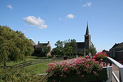 Schettens Church | |
 Flag  Coat of arms | |
 Location in the former Wûnseradiel municipality | |
53°4′57″N 5°28′59″E / 53.08250°N 5.48306°E / 53.08250; 5.48306 | |
| Country |  Netherlands Netherlands |
| Province |  Friesland Friesland |
| Municipality |  Súdwest-Fryslân Súdwest-Fryslân |
| Area | |
| • Total | 3.86 km2 (1.49 sq mi) |
| Elevation | 0.2 m (0.7 ft) |
| Population (2021)[1] | |
| • Total | 265 |
| • Density | 69/km2 (180/sq mi) |
| Postal code | 8744[1] |
| Dialing code | 0517 |
Schettens (West Frisian: Skettens) is a village in Súdwest-Fryslân in the province of Friesland, the Netherlands. It had a population of around 285 in January 2017.[3]
History
The village was first mentioned in 855 as Sceddanuurthi. The etymology is unclear.[4] Schettens is an old terp (artificial living hill) village near the former Marneslenk. Most of the terp has been excavated from 1830 onwards, and a stone wall has been built to protect the church.[5][6]
The Dutch Reformed church was built in 1865 as a replacement for the medieval church. The tower was demolished in 1816 or 1819 and temporarily replaced by a wooden tower. In 1877, a stone tower was built.[5]
Schettens was home to 95 people in 1840.[6] There was a school named C.B.S. De Trijetine but it got closed in 2018. Before 2011, the village was part of the Wûnseradiel municipality.[6]
Gallery
-
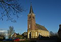 Protestant church of Schettens
 -
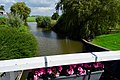 Canal view
 -
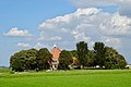 Farm near Schettens
 -
 House in Schettens


References
- ^ a b c "Kerncijfers wijken en buurten 2021". Central Bureau of Statistics. Retrieved 6 April 2022.
two entries
- ^ "Postcodetool for 8744EN". Actueel Hoogtebestand Nederland (in Dutch). Het Waterschapshuis. Retrieved 6 April 2022.
- ^ Kerncijfers wijken en buurten 2017 - CBS Statline
- ^ "Schettens - (geografische naam)". Etymologiebank (in Dutch). Retrieved 6 April 2022.
- ^ a b "Schettens". Friesland wonderland (in Dutch). Retrieved 6 April 2022.
- ^ a b c "Schettens". Plaatsengids (in Dutch). Retrieved 6 April 2022.
External links
![]() Media related to Schettens at Wikimedia Commons
Media related to Schettens at Wikimedia Commons
- v
- t
- e
Populated places in the municipality of Súdwest-Fryslân
- Abbegea
- Allingawier
- Arum
- Blauwhuis
- Boazum
- Breezanddijk
- Britswert
- Burgwerd
- Cornwerd
- Dearsum
- Dedgum
- Easterein
- Easterwierrum
- Exmorra
- Ferwoude
- Folsgare
- Gaast
- Gaastmeer
- Gauw
- Goënga
- Greonterp
- Hartwerd
- Heeg
- Hemelum
- Hichtum
- Hidaard
- Hieslum
- Hinnaard
- Hommerts
- Idsegahuizum
- Idzega
- Iens
- Indijk
- It Heidenskip
- Itens
- Jutrijp
- Kimswerd
- Kornwerderzand
- Koudum
- Koufurderrige
- Kûbaard
- Lollum
- Longerhouw
- Lytsewierrum
- Makkum
- Molkwerum
- Nijhuizum
- Nijland
- Oosthem
- Oppenhuizen
- Oudega
- Parrega
- Piaam
- Pingjum
- Poppenwier
- Reahûs
- Raerd
- Rien
- Sandfirden
- Scharl
- Scharnegoutum
- Schettens
- Schraard
- Sibrandabuorren
- Smallebrugge
- Tersoal
- Tirns
- Tjalhuizum
- Tjerkwerd
- Uitwellingerga
- Waaksens
- Warns
- Westhem
- Witmarsum
- Wiuwert
- Wolsum
- Wommels
- Wons
- Woudsend
- Ypecolsga
- Ysbrechtum
- Zurich
 | This Friesland location article is a stub. You can help Wikipedia by expanding it. |
- v
- t
- e


