Schkortleben
Stadtteil of Weißenfels in Saxony-Anhalt, Germany
Location of Schkortleben

51°15′N 12°1′E / 51.250°N 12.017°E / 51.250; 12.017
(2009-12-31)
06688
Schkortleben is a village and a former municipality in the Burgenlandkreis district, in Saxony-Anhalt, Germany. Since 1 September 2010, it is part of the town of Weißenfels. Until then, the village of Kriechau used to be part of Schkortleben.
Pictures of Kriechau
-
 Fire department at Kriechau
 -
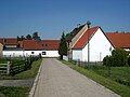
 Kriechau, Friedensstraße
 -
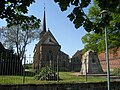 Church at Kriechau, neo-Gothic style, 19th century
 -
 Kriechau, area behind the church


References
Authority control databases | |
|---|---|
| International |
|
| National |
|
| Geographic |
|
- v
- t
- e


