Bruc-sur-Aff
Gemeente in Frankrijk  | |||
|---|---|---|---|
  | |||
| Situering | |||
| Regio | Bretagne | ||
| Departement | Ille-et-Vilaine (35) | ||
| Arrondissement | Redon | ||
| Kanton | Redon | ||
| Coördinaten | 47° 49′ NB, 2° 1′ WL | ||
| Algemeen | |||
| Oppervlakte | 21,23 km² | ||
| Inwoners (1 januari 2021) | 859 (40 inw./km²) | ||
| Hoogte | 12 - 84 m | ||
| Overig | |||
| Postcode | 35550 | ||
| INSEE-code | 35045 | ||
| Website | Officiële website | ||
| Detailkaart | |||
 | |||
| Foto's | |||
 | |||
| Église Saint-Michel | |||
| |||

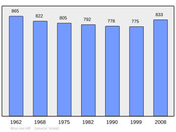
Bruc-sur-Aff is een gemeente in het Franse departement Ille-et-Vilaine (regio Bretagne) en telt 775 inwoners (1999). De plaats maakt deel uit van het arrondissement Redon.
Geografie
De oppervlakte van Bruc-sur-Aff bedraagt 21,0 km², de bevolkingsdichtheid is 36,9 inwoners per km².

Demografie
Onderstaande figuur toont het verloop van het inwonertal (bron: INSEE-tellingen).
Mediabestanden
Zie de categorie Bruc-sur-Aff van Wikimedia Commons voor mediabestanden over dit onderwerp.


