Grade II* listed buildings in the City of Carlisle
Map all coordinates using OpenStreetMap
Download coordinates as:
- KML
- GPX (all coordinates)
- GPX (primary coordinates)
- GPX (secondary coordinates)
There are over 20,000 Grade II* listed buildings in England. This page is a list of these buildings in the City of Carlisle in Cumbria.
List of buildings
| Name | Location | Type | Completed [note 1] | Date designated | Grid ref.[note 2] Geo-coordinates | Entry number [note 3] | Image |
|---|---|---|---|---|---|---|---|
| Brackenhill Tower | Arthuret | House | 1586 | 1 April 1957 | NY4458169480 55°01′00″N 2°52′06″W / 55.016764°N 2.868229°W / 55.016764; -2.868229 (Brackenhill Tower) | 1087521 |  More images |
| Church of St Michael | Arthuret | Church | 1609 | 1 April 1957 | NY3793967666 54°59′59″N 2°58′18″W / 54.99968°N 2.971692°W / 54.99968; -2.971692 (Church of St Michael) | 1087523 | 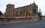 More images |
| Churchyard cross west of Church of St Michael | Arthuret | Cross | 12th or 13th century | 15 June 1984 | NY3788967655 54°59′58″N 2°58′21″W / 54.999575°N 2.972472°W / 54.999575; -2.972472 (Churchyard cross west of Church of St Michael) | 1087524 |  Upload Photo |
| Coop House, north-west of Netherby Hall | Netherby, Arthuret | Estate cottage | Mid-18th century | 15 June 1984 | NY3866971474 55°02′02″N 2°57′40″W / 55.033985°N 2.961101°W / 55.033985; -2.961101 (Coop House, north-west of Netherby Hall) | 1204976 |  More images |
| Netherby Hall | Netherby, Arthuret | House | 15th century and later | 1 April 1957 | NY3966371613 55°02′07″N 2°56′44″W / 55.035356°N 2.945581°W / 55.035356; -2.945581 (Netherby Hall) | 1204948 |  More images |
| Church of St Mary | Beaumont | Church | Late 12th century | 1 May 1957 | NY3481159298 54°55′27″N 3°01′07″W / 54.924095°N 3.018677°W / 54.924095; -3.018677 (Church of St Mary) | 1335624 | 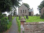 More images |
| Church of St Cuthbert | Bewcastle | Church | 13th century | 1 April 1957 | NY5654274561 55°03′49″N 2°40′55″W / 55.063611°N 2.681963°W / 55.063611; -2.681963 (Church of St Cuthbert) | 1087539 |  More images |
| Church of St Martin (Brampton Old Church) | Brampton | Church | 12th century | 1 April 1951 | NY5101461557 54°56′47″N 2°45′59″W / 54.94625°N 2.766276°W / 54.94625; -2.766276 (Church of St Martin (Brampton Old Church)) | 1087645 |  More images |
| Four Gables | Brampton | House | 1879 | 13 February 1963 | NY5434661632 54°56′50″N 2°42′51″W / 54.94724°N 2.714275°W / 54.94724; -2.714275 (Four Gables) | 1087651 | Upload Photo |
| Moot Hall | Brampton, Brampton | Moot hall | 1817 | 1 April 1957 | NY5307461088 54°56′32″N 2°44′03″W / 54.942234°N 2.734043°W / 54.942234; -2.734043 (Moot Hall) | 1137330 | 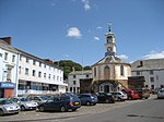 More images |
| Old Church Farmhouse | Brampton | Farmhouse | Early 14th century | 16 January 1984 | NY5102861598 54°56′48″N 2°45′58″W / 54.946619°N 2.766065°W / 54.946619; -2.766065 (Old Church Farmhouse) | 1087646 | Upload Photo |
| Barn adjoining to north of Moorhouse Farmhouse | Moorhouse, Burgh By Sands | Barn | Late 17th century | 22 November 1973 | NY3298856826 54°54′06″N 3°02′48″W / 54.901643°N 3.04654°W / 54.901643; -3.04654 (Barn adjoining to north of Moorhouse Farmhouse) | 1335655 | Upload Photo |
| King Edward I Monument | Sandsfield, Burgh By Sands | Commemorative monument | 1685 | 1 April 1957 | NY3257460920 54°56′18″N 3°03′14″W / 54.938371°N 3.053956°W / 54.938371; -3.053956 (King Edward I Monument) | 1087463 |  More images |
| Lamonby Farmhouse and adjoining barn | Burgh By Sands | Farmhouse | Mid-17th century | 19 September 1984 | NY3270859170 54°55′22″N 3°03′05″W / 54.922666°N 3.051455°W / 54.922666; -3.051455 (Lamonby Farmhouse and adjoining barn) | 1039874 |  More images |
| Church of St Michael and All Angels | Dalston | Church | 12th century | 19 September 1984 | NY3694450162 54°50′32″N 2°59′00″W / 54.842283°N 2.9834°W / 54.842283; -2.9834 (Church of St Michael and All Angels) | 1374153 |  More images |
| Dalston Hall | Dalston | Fortified house | 1433–99 | 19 September 1984 | NY3765851566 54°51′18″N 2°58′21″W / 54.854987°N 2.972587°W / 54.854987; -2.972587 (Dalston Hall) | 1087441 |  More images |
| Dovecote to north-east of Rose Castle | Dalston | Dovecote | 1700 | 19 September 1984 | NY3712546348 54°48′29″N 2°58′47″W / 54.808036°N 2.979752°W / 54.808036; -2.979752 (Dovecote to north-east of Rose Castle) | 1087474 | Upload Photo |
| Hawkesdale Hall | Hawkesdale, Dalston | House | Late 17th century | 19 September 1984 | NY3746447710 54°49′13″N 2°58′29″W / 54.820316°N 2.974773°W / 54.820316; -2.974773 (Hawkesdale Hall) | 1335649 | Upload Photo |
| Church of St Mary Magdalen | Hayton | Church | 1780 | 1 April 1957 | NY5078657692 54°54′41″N 2°46′09″W / 54.911498°N 2.769172°W / 54.911498; -2.769172 (Church of St Mary Magdalen) | 1335622 |  More images |
| Gelt Bridge | Hayton | Railway bridge | 1832–35 | 1 April 1957 | NY5324757324 54°54′30″N 2°43′51″W / 54.908429°N 2.730729°W / 54.908429; -2.730729 (Gelt Bridge) | 1335587 |  More images |
| Church of St Kentigern | Irthington | Church | 12th century | 1 April 1957 | NY4987661634 54°56′49″N 2°47′03″W / 54.946828°N 2.784054°W / 54.946828; -2.784054 (Church of St Kentigern) | 1335584 |  More images |
| Church of St Andrew | Kirkandrews on Esk | Church | 1776 | 1 April 1957 | NY3911071982 55°02′19″N 2°57′16″W / 55.038604°N 2.954311°W / 55.038604; -2.954311 (Church of St Andrew) | 1087506 |  More images |
| Kirkandrews Tower | Kirkandrews on Esk | House | 18th century | 1 April 1957 | NY3891471928 55°02′17″N 2°57′27″W / 55.038095°N 2.957366°W / 55.038095; -2.957366 (Kirkandrews Tower) | 1205396 |  More images |
| Riddings Junction Viaduct | Kirkandrews on Esk | Railway viaduct | 1864 | 31 October 1996 | NY4107275585 55°04′16″N 2°55′28″W / 55.071213°N 2.924361°W / 55.071213; -2.924361 (Riddings Junction Viaduct) | 1268307 |  More images |
| Church of St Cuthbert | Kirklinton | Church | 1845 | 16 January 1984 | NY4326667038 54°59′41″N 2°53′18″W / 54.994674°N 2.888306°W / 54.994674; -2.888306 (Church of St Cuthbert) | 1335549 |  More images |
| Tarn House | Midgeholme | Farmhouse | Late 15th century | 1 April 1957 | NY6061358486 54°55′10″N 2°36′58″W / 54.919507°N 2.61601°W / 54.919507; -2.61601 (Tarn House) | 1051067 | 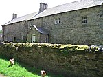 More images |
| Stonegarthside Hall | Nicholforest | House | 1682 | 15 June 1984 | NY4803981860 55°07′42″N 2°48′59″W / 55.128374°N 2.816418°W / 55.128374; -2.816418 (Stonegarthside Hall) | 1335605 |  More images |
| Church of St Giles | Great Orton, Orton | Church | 12th century | 19 September 1984 | NY3289454287 54°52′44″N 3°02′51″W / 54.878818°N 3.047413°W / 54.878818; -3.047413 (Church of St Giles) | 1087417 |  More images |
| Castletown | Rockcliffe | House | 1811 | 1 April 1957 | NY3480662098 54°56′57″N 3°01′10″W / 54.949252°N 3.019392°W / 54.949252; -3.019392 (Castletown) | 1087596 | Upload Photo |
| Church of St Mary | Rockcliffe | Church | 1848 | 1 April 1957 | NY3588061643 54°56′43″N 3°00′09″W / 54.945303°N 3.002525°W / 54.945303; -3.002525 (Church of St Mary) | 1087594 |  More images |
| Church of St Mary | Wreay, St. Cuthbert Without | Church | 1840–42 | 1 April 1957 | NY4352548921 54°49′55″N 2°52′51″W / 54.831919°N 2.880696°W / 54.831919; -2.880696 (Church of St Mary) | 1087758 |  More images |
| Newbiggin Hall | St. Cuthbert Without | House | Early 19th century | 14 September 1954 | NY4330350858 54°50′57″N 2°53′04″W / 54.849298°N 2.884532°W / 54.849298; -2.884532 (Newbiggin Hall) | 1087720 |  More images |
| Brunstock House | Brunstock, Stanwix Rural | House | 1827–33 | 22 September 1983 | NY4188159419 54°55′34″N 2°54′30″W / 54.926057°N 2.908405°W / 54.926057; -2.908405 (Brunstock House) | 1087726 | Upload Photo |
| Drawdykes Castle | Drawdykes, Stanwix Rural | Farmhouse | c.1764 | 1 April 1957 | NY4190758549 54°55′06″N 2°54′28″W / 54.918243°N 2.907823°W / 54.918243; -2.907823 (Drawdykes Castle) | 1087728 | Upload Photo |
| Linstock Castle | Linstock, Stanwix Rural | Farmhouse, former tower house | 12th or early 13th century | 1 April 1957 | NY4289758484 54°55′04″N 2°53′33″W / 54.917773°N 2.892367°W / 54.917773; -2.892367 (Linstock Castle) | 1119608 |  More images |
| Temon and adjoining outbuilding | Upper Denton | Farmhouse | Late 17th century | 1 April 1957 | NY6169963825 54°58′03″N 2°35′59″W / 54.967566°N 2.599782°W / 54.967566; -2.599782 (Temon and adjoining outbuilding) | 1087520 |  More images |
| Upper Denton Church | Upper Denton | Church | Early 12th century | 1 April 1957 | NY6156065514 54°58′58″N 2°36′08″W / 54.982732°N 2.602181°W / 54.982732; -2.602181 (Upper Denton Church) | 1087564 |  More images |
| Church of St Mary | Walton | Church | 1869–70 | 16 January 1984 | NY5221664490 54°58′22″N 2°44′53″W / 54.972721°N 2.748003°W / 54.972721; -2.748003 (Church of St Mary) | 1157868 | 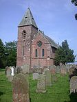 More images |
| Church of St Leonard | Warwick, Wetheral | Church | 12th century | 1 April 1957 | NY4660056800 54°54′11″N 2°50′03″W / 54.903052°N 2.834293°W / 54.903052; -2.834293 (Church of St Leonard) | 1121876 |  More images |
| Church of St Mary and St Wilfred | Warwick Bridge, Wetheral | Roman Catholic church | 1841 | 1 April 1957 | NY4752156817 54°54′12″N 2°49′12″W / 54.903303°N 2.819934°W / 54.903303; -2.819934 (Church of St Mary and St Wilfred) | 1111897 |  More images |
| Church of the Holy Trinity and St Constantine | Wetheral | Church | 13th century | 1 April 1957 | NY4681754401 54°52′53″N 2°49′50″W / 54.88152°N 2.830465°W / 54.88152; -2.830465 (Church of the Holy Trinity and St Constantine) | 1087692 |  More images |
| Holme Eden Abbey | Warwick Bridge, Wetheral | Abbey | 1833–37 | 3 September 1973 | NY4717957001 54°54′18″N 2°49′31″W / 54.90492°N 2.825301°W / 54.90492; -2.825301 (Holme Eden Abbey) | 1087685 |  More images |
| Statue of Polyphemus, Corby Castle | Great Corby, Wetheral | Statue | Early 18th century | 22 September 1983 | NY4706654039 54°52′42″N 2°49′35″W / 54.878294°N 2.826518°W / 54.878294; -2.826518 (Statue of Polyphemus, Corby Castle) | 1087675 | Upload Photo |
| The Corn Mill | Warwick Bridge, Wetheral | Watermill | 1839 | 22 September 1983 | NY4741656908 54°54′15″N 2°49′18″W / 54.90411°N 2.821588°W / 54.90411; -2.821588 (The Corn Mill) | 1087686 |  More images |
| Bishop's Registry | The Abbey | Library | 1699 | 1 June 1949 | NY3981255942 54°53′40″N 2°56′24″W / 54.89457°N 2.939956°W / 54.89457; -2.939956 (Bishop's Registry) | 1197012 |  More images |
| Church of St Cuthbert with St Mary | Carlisle | Church | 1778 | 1 June 1949 | NY3996455843 54°53′37″N 2°56′15″W / 54.893699°N 2.937565°W / 54.893699; -2.937565 (Church of St Cuthbert with St Mary) | 1218565 |  More images |
| Citadel Station | Carlisle | Railway station | 1847–48 | 13 November 1972 | NY4023655540 54°53′28″N 2°56′00″W / 54.891009°N 2.933262°W / 54.891009; -2.933262 (Citadel Station) | 1196969 |  More images |
| Coledale Hall | Carlisle | House | 1810 | 1 June 1949 | NY3836755999 54°53′42″N 2°57′45″W / 54.894906°N 2.962494°W / 54.894906; -2.962494 (Coledale Hall) | 1196932 |  More images |
| Congregational Church | Carlisle | Church | 1842–43 | 22 March 1974 | NY4026755752 54°53′35″N 2°55′58″W / 54.892918°N 2.932823°W / 54.892918; -2.932823 (Congregational Church) | 1196929 |  More images |
| Cumberland Infirmary | Carlisle | Hospital | 1830–32 | 13 November 1972 | NY3883156084 54°53′45″N 2°57′19″W / 54.895727°N 2.955279°W / 54.895727; -2.955279 (Cumberland Infirmary) | 1218237 |  More images |
| Dixons Chimney at Shaddon Mill | Carlisle | Cotton mill | 1836 | 13 November 1972 | NY3946255644 54°53′31″N 2°56′43″W / 54.89185°N 2.945349°W / 54.89185; -2.945349 (Dixons Chimney at Shaddon Mill) | 1196919 |  More images |
| Monument to Peter Nicholson, north-west of cemetery chapel | Carlisle | Commemorative monument | 1855–56 | 11 April 1994 | NY3911354377 54°52′50″N 2°57′02″W / 54.880424°N 2.950521°W / 54.880424; -2.950521 (Monument to Peter Nicholson, north-west of cemetery chapel) | 1218406 | Upload Photo |
| Mulcaster House | Carlisle | House | Late 18th century | 1 June 1949 | NY4022057035 54°54′16″N 2°56′02″W / 54.90444°N 2.933823°W / 54.90444; -2.933823 (Mulcaster House) | 1196986 | Upload Photo |
| No 32 Abbey Street and railings to front | Carlisle | House | c.1817 | 1 June 1949 | NY3974255984 54°53′42″N 2°56′28″W / 54.894939°N 2.941056°W / 54.894939; -2.941056 (No 32 Abbey Street and railings to front) | 1293020 |  More images |
| Nos 26, 28 and 30 Castle Street and railings to front | Carlisle | Apartment | 1823 | 1 June 1949 | NY3981956047 54°53′44″N 2°56′24″W / 54.895515°N 2.939869°W / 54.895515; -2.939869 (Nos 26, 28 and 30 Castle Street and railings to front) | 1355058 | 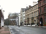 |
| Petteril Bank (now Cumbria Archives) | Carlisle | House | 1829 | 11 April 1994 | NY4160153628 54°52′26″N 2°54′42″W / 54.873991°N 2.911597°W / 54.873991; -2.911597 (Petteril Bank (now Cumbria Archives)) | 1297373 |  More images |
| Shaddon Mill | Carlisle | Cotton mill | 1835–36 | 1 June 1949 | NY3951455628 54°53′30″N 2°56′40″W / 54.891713°N 2.944535°W / 54.891713; -2.944535 (Shaddon Mill) | 1297383 |  More images |
| Trustee Savings (now Lloyds) Bank and attached railings | Carlisle | Bank | 1874 | 1 June 1949 | NY4026355779 54°53′35″N 2°55′58″W / 54.89316°N 2.932891°W / 54.89316; -2.932891 (Trustee Savings (now Lloyds) Bank and attached railings) | 1196930 | 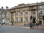 More images |
| 18 Fisher Street | Carlisle | House | Late 18th century | 1 June 1949 | NY3993456094 54°53′45″N 2°56′17″W / 54.895951°N 2.938086°W / 54.895951; -2.938086 (18 Fisher Street) | 1196951 | Upload Photo |
| 26 Abbey Street | Carlisle | House | Late 18th century | 1 June 1949 | NY3972255993 54°53′42″N 2°56′29″W / 54.895018°N 2.941369°W / 54.895018; -2.941369 (26 Abbey Street) | 1196981 |  |
| 2 The Abbey | Carlisle | Clergy house | Late 17th century | 1 June 1949 | NY3982955956 54°53′41″N 2°56′23″W / 54.894698°N 2.939694°W / 54.894698; -2.939694 (2 The Abbey) | 1197013 |  More images |
| 21 Castle Street | Carlisle | House | Late 18th century | 1 June 1949 | NY3988356044 54°53′44″N 2°56′20″W / 54.895495°N 2.93887°W / 54.895495; -2.93887 (21 Castle Street) | 1297358 |  More images |
| 24 Abbey Street | Carlisle | House | Early 19th century | 1 June 1949 | NY3971656002 54°53′42″N 2°56′29″W / 54.895098°N 2.941465°W / 54.895098; -2.941465 (24 Abbey Street) | 1297355 |  |
| 19, 21 and 23 Victoria Place | Carlisle | House | Early 1870s | 13 November 1972 | NY4035356001 54°53′43″N 2°55′54″W / 54.895165°N 2.931534°W / 54.895165; -2.931534 (19, 21 and 23 Victoria Place) | 1197137 | Upload Photo |
| 2 Albert Street | Carlisle | Terrace | 1852–54 | 1 June 1949 | NY4031856035 54°53′44″N 2°55′56″W / 54.895467°N 2.932087°W / 54.895467; -2.932087 (2 Albert Street) | 1297274 | Upload Photo |
| 3 and 6 The Abbey | Carlisle | Clergy house | Late 17th century | 1 June 1949 | NY3994355915 54°53′40″N 2°56′16″W / 54.894343°N 2.937908°W / 54.894343; -2.937908 (3 and 6 The Abbey) | 1293105 |  More images |
| 3–17 Victoria Place | Carlisle | Terrace | Late 1840s | 1 June 1949 | NY4028255981 54°53′42″N 2°55′57″W / 54.894977°N 2.932637°W / 54.894977; -2.932637 (3–17 Victoria Place) | 1197136 | Upload Photo |
| 2 Victoria Place | Carlisle | House | 1830s | 13 November 1972 | NY4025256022 54°53′43″N 2°55′59″W / 54.895342°N 2.933113°W / 54.895342; -2.933113 (2 Victoria Place) | 1218796 | Upload Photo |
| 1 Victoria Place | Carlisle | House | 1830s | 13 November 1972 | NY4026855981 54°53′42″N 2°55′58″W / 54.894975°N 2.932855°W / 54.894975; -2.932855 (1 Victoria Place) | 1196918 | Upload Photo |
| Cumberland and Westmorland Joint Counties’ War Memorial | Rickerby Park, Carlisle | War memorial | 1922 | 11 April 1994 | NY4090956844 54°54′10″N 2°55′23″W / 54.902806°N 2.9230396°W / 54.902806; -2.9230396 (Cumberland and Westmorland Joint Counties’ War Memorial) | 1291971 |  More images |
See also
- Grade II* listed buildings in Cumbria
- Grade II* listed buildings in Allerdale
- Grade II* listed buildings in Barrow-in-Furness (borough)
- Grade II* listed buildings in Copeland
- Grade II* listed buildings in Eden
- Grade II* listed buildings in South Lakeland
- Grade I listed buildings in Cumbria
Notes
- ^ The date given is the date used by Historic England as significant for the initial building or that of an important part in the structure's description.
- ^ Sometimes known as OSGB36, the grid reference is based on the British national grid reference system used by the Ordnance Survey.
- ^ The "List Entry Number" is a unique number assigned to each listed building and scheduled monument by Historic England.
External links
- v
- t
- e
- Bedfordshire
- Berkshire
- Bristol
- Buckinghamshire
- Cambridgeshire
- Cheshire
- Cornwall
- Cumbria
- Derbyshire
- Devon
- Dorset
- Durham
- East Sussex
- East Riding of Yorkshire
- Essex
- Gloucestershire
- Greater London
- Greater Manchester
- Hampshire
- Herefordshire
- Hertfordshire
- Isle of Wight
- Kent
- Lancashire
- Leicestershire
- Lincolnshire
- Merseyside
- Norfolk
- North Yorkshire
- Northamptonshire
- Northumberland
- Nottinghamshire
- Oxfordshire
- Rutland
- Shropshire
- Somerset
- South Yorkshire
- Staffordshire
- Suffolk
- Surrey
- Tyne and Wear
- Warwickshire
- West Midlands
- West Sussex
- West Yorkshire
- Wiltshire
- Worcestershire
- Allerdale
- Amber Valley
- Ashford
- Babergh
- Barrow-in-Furness
- Basildon
- Basingstoke and Deane
- Bath and North East Somerset
- Bolsover
- Boston
- Bournemouth
- Bradford
- Braintree
- Breckland
- Brentwood
- Brighton and Hove
- Bristol
- Broadland
- Calderdale
- Cambridge
- Camden
- Canterbury
- Carlisle
- Castle Point
- Chelmsford
- Cheltenham
- Cherwell
- Cheshire East
- Cheshire West and Chester
- Chesterfield
- Chiltern
- Christchurch
- Colchester
- Copeland
- Corby
- Cotswold
- Dartford
- Daventry
- Dover
- East Cambridgeshire
- Exeter
- Mendip
- North Somerset
- North Yorkshire (district)
- Poole
- Sedgemoor
- South Somerset
- Stoke-on-Trent
- Taunton Deane
- West Somerset
- York


